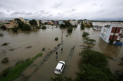
Chennai, (Samajweekly) In December 2023, to be precise on December 17 and 18, in the course of the north east monsoon, Tirunelveli, a coastal district in south Tamil Nadu, witnessed a record breaking rainfall of 123.9 cm.
Data from the Regional Meteorological Centre (RMC) states that this was 146% higher than the seasonal average of 50.3 cm.
On December 18, 2023, a weather station in Kayalpattinam in Thoothukudi district (again in South Tamil Nadu) recorded 94.6 cm, the highest rainfall ever witnessed in 24 hours during the north east monsoon (NEM) in Tamil Nadu. This new observation is equivalent to 90% of the usual rainfall received by the entire district in a year.
Such extreme rainfall is usual during severe cyclones but the record breaking rainfall in South Tamil Nadu that created havoc in the districts of Thoothukudi, Tirunelveli, Tenkasi and Kanniyakumari was due to an upper air circulation as per the Regional Meteorological Centre deputy director, S. Balachandran.
Weather forecasting models can accurately predict up to and above 20 cm rainfall in a day and RMC predicts rainfall in three categories: heavy (6 to 11 cm); very heavy (12 to 19 cm) and extreme (20 cm and above).
“The closest comparison to the extreme rainfall event at Kayalpattinam in recent years is from May 6, 2004, when Aminidivi at Lakshadweep recorded 116.8 cm and July 27, 2005, when Vihar lake in Mumbai received 104.9 cm. While the Lakshadweep event happened when a cyclone passed near the islands, the Mumbai rains happened during the southwest monsoon which is generally a much larger phenomenon compared to NEM in India, according to Thoothukudi based weather expert and blogger Rajeev Nath.
According to climatologists it was the bare minimum system that caused such intense rainfall in southern Tamil Nadu. A bare minimum system is an event that is classified as a weak disturbance and extreme rainfall is not usually predicted at that time.
Rajeev Nath said that the heavy rainfall that was witnessed in Tamil Nadu was upper air circulation and that the rains came in isolated locations such as Kayalpattinam which could be attributed to climate change.
Climate expert Sumathi Menon, while speaking to IANS said ,”A majority of the heat generated due to global warming is absorbed by our oceans, leading to a steep rise in sea surface temperatures and these increased temperatures cause the ocean to release more moisture into the atmosphere.”
She stated that the moisture-laden air moves slowly and similar conditions were thus seen over isolated regions of Tamil Nadu such as Kayalpattinam.
Climate researchers also said that the pattern of air circulation during the NEM has been changing in the past ten years, owing to heavy emission of carbon dioxide and global air circulation patterns are influenced by changes in greenhouse gas emissions.
Climate expert and former Professor in Physics of Tiruchy government college, Dr. Selvakumar while speaking to IANS said, “The warming potential in the atmosphere has been increasing alarmingly and the atmospheric behaviour is altered gradually due to global air circulation, which in turn has a heavy impact on oceanic air circulation.”
He said that this resulted in changing monsoon patterns leading to climate extremes.
Several studies also reiterate the occurrence of drastic warming of oceans. The Environmental Development has in a study published in 2016 identified the northern Indian ocean as one of the 17 climate change hotspots among the world oceans. These areas are seen to be warming faster than the remaining 90% of the oceans,
Selvakumar said that global warming affects the solubility of gases, including oxygen and the exchange of gases between the ocean surface and the atmosphere.
He also warned that sea surface temperatures (SST) have increased by 0.2-0.3°C along the Indian coast in the Bay of Bengal during a 45-year period from 1960 to 2005. The study predicts an increase of 2–3.5 °C by the end of the century.
The year 2023 was an El Nino year. El Nino is a natural phenomenon that creates a warming effect in the Pacific Ocean periodically.
Dr. N. Rajeevan, earth scientist in the US and hailing from Kannur in Kerala told IANS that “The El Niño pattern this year is different than the usual one and thus its impact on the southwest and northeast monsoons is not as expected.” He added that global warming and El Nino work in tandem and that the warming conditions have led to a stronger El Nino phenomenon.
Intense rains can also happen in the context of global warming. Dr. Geetha Iyer who is an environmental scientist in Chennai while speaking to IANS said, “Due to global warming large scale moisture convergence takes place. There is more water vapour which leads to large-scale convergence. This causes more precipitation. If we get heavy rains in Kerala it’s a regular phenomenon except when the rains are that heavy. But in places like Thoothukudi and Tiruneveli receiving such rains could be due to global warming and local events can be due to local topography and the synoptic systems prevailing there.”